


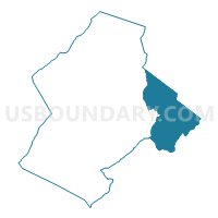
Roaring Run Voting District, Botetourt County, Virginia
About
Outline

Summary
| Unique Area Identifier | 681182 |
| Name | Roaring Run Voting District |
| County | Botetourt County |
| State | Virginia |
| Area (square miles) | 66.83 |
| Land Area (square miles) | 66.42 |
| Water Area (square miles) | 0.41 |
| % of Land Area | 99.38 |
| % of Water Area | 0.62 |
| Latitude of the Internal Point | 37.53190530 |
| Longtitude of the Internal Point | -79.60654940 |
Maps

Graphs
Select a template below for downloading or customizing gragh for Roaring Run Voting District, Botetourt County, Virginia


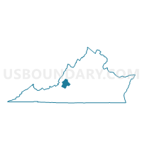
Neighbors
Neighoring Voting District (by Name) Neighboring Voting District on the Map
- Buchanan Voting District, Botetourt County, VA
- Effinger Voting District, Rockbridge County, VA
- Montvale Elem School Voting District, Bedford County, VA
- Natural Bridge Voting District, Rockbridge County, VA
- Odd Fellows Hall Voting District, Bedford County, VA
- Plank Road Voting District, Rockbridge County, VA
- Sedalia Center Voting District, Bedford County, VA
- Thaxton Elem School Voting District, Bedford County, VA
Top 10 Neighboring County Subdivision (by Population) Neighboring County Subdivision on the Map
- Blue Ridge district, Bedford County, VA (14,811)
- Peaks district, Bedford County, VA (7,116)
- Buchanan district, Botetourt County, VA (6,306)
- Kerrs Creek district, Rockbridge County, VA (4,989)
- Buffalo district, Rockbridge County, VA (4,369)
- Natural Bridge district, Rockbridge County, VA (3,042)
Top 10 Neighboring Unified School District (by Population) Neighboring Unified School District on the Map
- Bedford County Public Schools, VA (68,676)
- Botetourt County Public Schools, VA (33,148)
- Rockbridge County Public Schools, VA (22,307)
Top 10 Neighboring State Legislative District Lower Chamber (by Population) Neighboring State Legislative District Lower Chamber on the Map
Top 10 Neighboring State Legislative District Upper Chamber (by Population) Neighboring State Legislative District Upper Chamber on the Map
- State Senate District 23, VA (202,433)
- State Senate District 25, VA (194,804)
- State Senate District 22, VA (193,582)
Top 10 Neighboring 111th Congressional District (by Population) Neighboring 111th Congressional District on the Map
Top 10 Neighboring Census Tract (by Population) Neighboring Census Tract on the Map
- Census Tract 9303, Rockbridge County, VA (6,434)
- Census Tract 402, Botetourt County, VA (4,294)
- Census Tract 9304, Rockbridge County, VA (3,945)
- Census Tract 303, Bedford County, VA (3,739)
- Census Tract 401, Botetourt County, VA (3,498)
- Census Tract 306.05, Bedford County, VA (3,311)
- Census Tract 304.01, Bedford County, VA (2,905)
Top 10 Neighboring 5-Digit ZIP Code Tabulation Area (by Population) Neighboring 5-Digit ZIP Code Tabulation Area on the Map
- 24523, VA (18,952)
- 24450, VA (16,741)
- 24066, VA (4,883)
- 24122, VA (1,683)
- 24579, VA (1,389)
- 24578, VA (1,056)